

![[HOME]](/netaicon/homeicon.gif)
![[SEARCH]](/netaicon/srchpage.gif)

![[CURR_LIST]](/netaicon/curlist.gif)


![[BOTTOM]](/netaicon/bottom.gif)

![[HELP]](/netaicon/help.gif)
Seattle Municipal Archives Map Index
 Seattle Municipal Archives Map Index
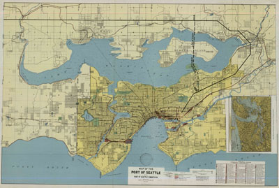
 Item No: 864
Title: Map of the Port of Seattle
Author: Port of Seattle Commission
Published: Seattle: Port of Seattle, 1918
Description: 1 map ; 70 x 105 cm. Paper.
Scale: 1:34200
Scope of information on map: Streets
Base date: 1918
Date of last change: Dec 6, 1937
Notes: Key lists labelled wharves and industrial facilities.
Inset map shows birdseye view of Seattle in Puget Sound.
Condition: Folded
Context: . Removed from CF 157354.. High Resolution TIFF
available. Downloadable High Resolution JPEG 4.0 MB.
Record series code: 1802-01
Location: F-1-1-1
Subjects: MARINE-TERMINALS, RAILROADS, PORT-OF-SEATTLE,
MERCER-ISLAND, SKAGIT-PROJECT, TRANSMISSION-LINES, LAKE-WASHINGTON,
RIGHT-OF-WAY, RENTON, PLANNING, LAND-ACQUISITION, CONDEMNATION
Medium
resolution copy of this map, about 1200 pixels in its long dimension, file
size 100-400 KB.
High resolution
copy of this map, file size 1-2 MB.