

![[HOME]](/netaicon/homeicon.gif)
![[SEARCH]](/netaicon/srchpage.gif)

![[CURR_LIST]](/netaicon/curlist.gif)


![[BOTTOM]](/netaicon/bottom.gif)

![[HELP]](/netaicon/help.gif)
Seattle Municipal Archives Map Index
 Seattle Municipal Archives Map Index
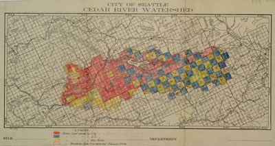
 Item No: 1717
Title: City of Seattle Cedar River Watershed
Author: Seattle Water Department
Description: 1 map; 29 x 56 cm. Printed on paper with ink
and colored pencil.
Scale: 1:120000
Scope of information on map: Survey boundaries; Land
ownership
Date: Jun 15, 1920
Context: .
Record series code: 8200-10
Location: F-10-4-2
Subjects: CEDAR-RIVER-WATERSHED
Medium
resolution copy of this map, about 1200 pixels in its long dimension, file
size 100-400 KB.
High resolution
copy of this map, file size 1-2 MB.